 Climaviso
Spain in six maps: what the severe-weather warnings say
Published 22 October 2026 · Climaviso
Spain has 182 warning zones, and each has its own bad weather. Heat rules the centre and south; rain, the coasts and the north; storms, the Iberian mountains. These six maps show it zone by zone, from the warnings of the last seven full years (2019–2025).
1. Each zone's most common warning
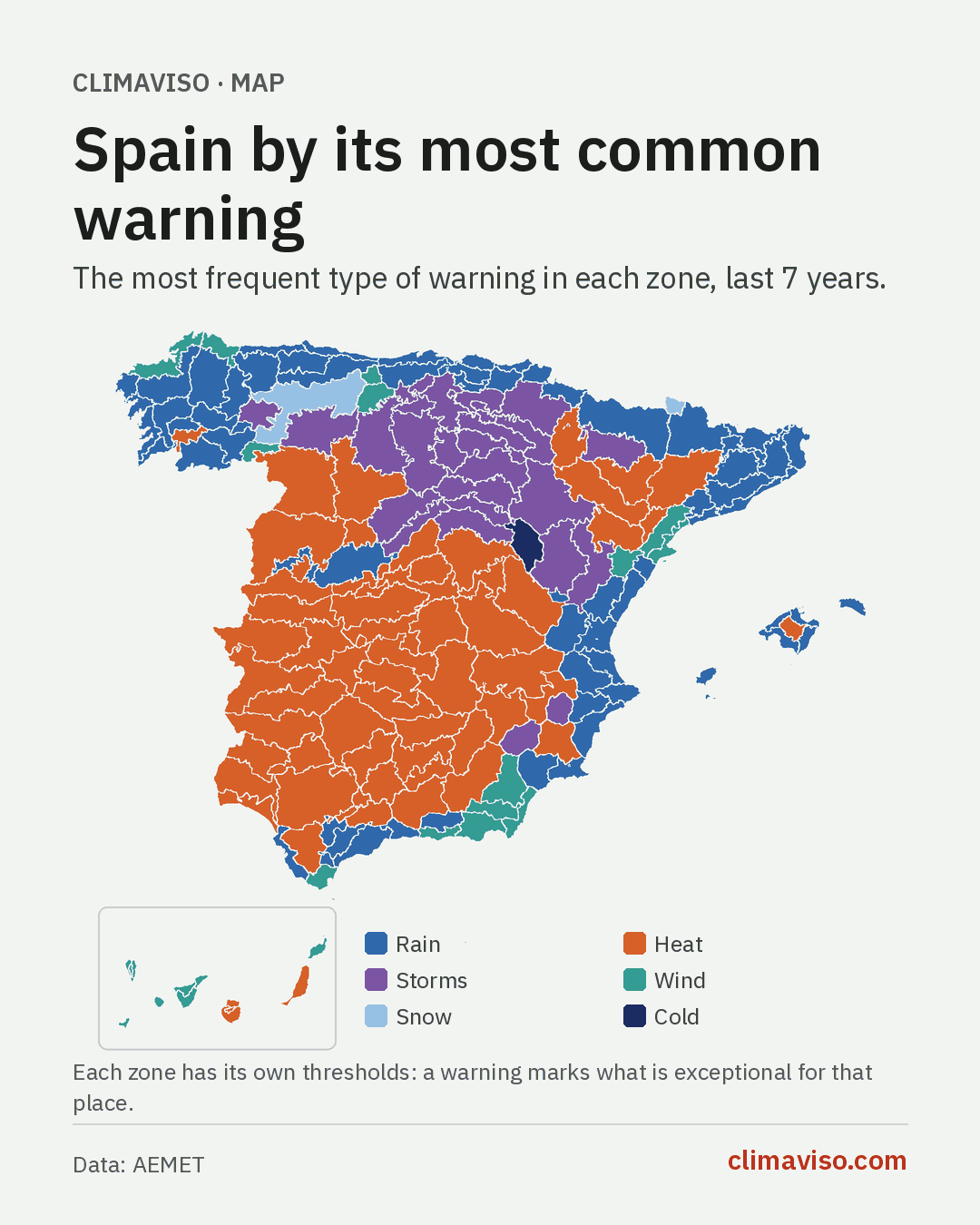
Rain is the most common warning in 66 zones and heat in 62. Between them they cover almost the whole map: heat holds the interior and the south, from Extremadura to Murcia and from the Ebro valley to the Seville countryside; rain holds the whole Cantabrian coast, Galicia, Catalonia and the Valencian coast.
Storms come first in 27 zones, almost all in the Iberian mountains and the northern plateau, where summer brings storms nearly every day. Wind comes first in 24, mostly in the Canary Islands, Almería, the north coast of Galicia and southern Tarragona and Castellón. Winter rules in only three zones: snow in the Val d'Aran and the Cantabrian mountains of León, and cold in the Parameras de Molina (Guadalajara).
2. Heat Spain and rain Spain
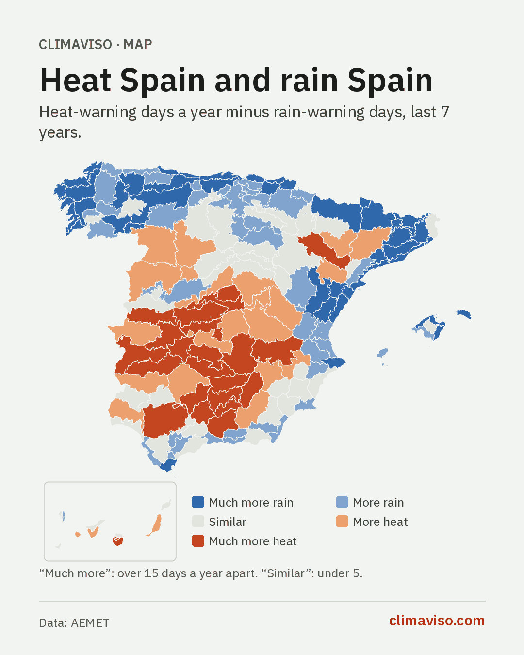
Take each zone's rain-warning days away from its heat-warning days and Spain splits in two. 85 zones clearly get more rain warnings (at least five more days a year) and 50 clearly get more heat warnings. The other 47 are close to even.
The line runs between coast and interior rather than north and south: the Mediterranean coast from Girona to Alicante falls on the rain side, like Galicia and the Cantabrian coast. Deep red gathers in the Guadalquivir valley, La Mancha, Extremadura and Madrid.
3. The season with the most warnings
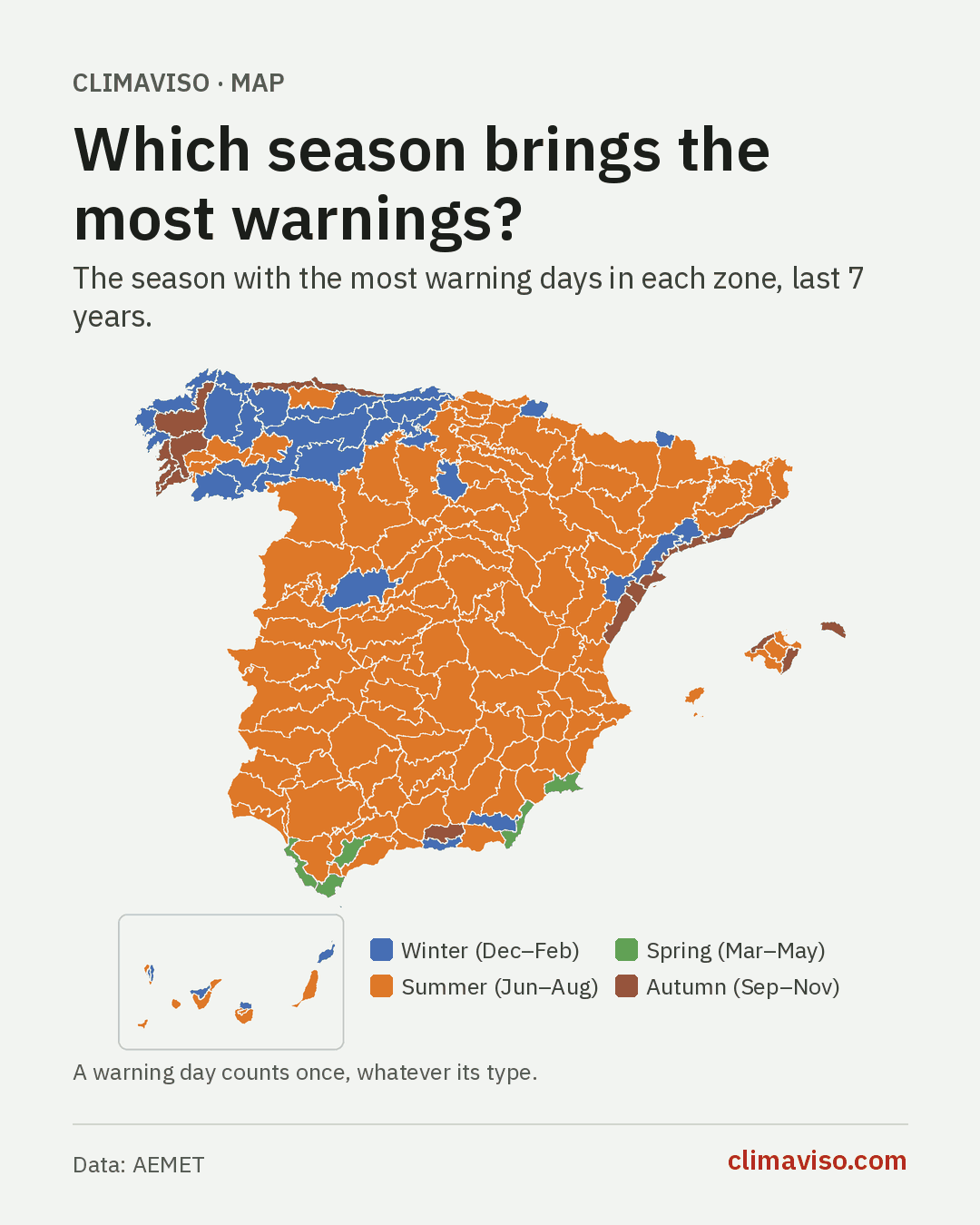
In 126 of the 182 zones, summer is the season with the most warning days. But the map has clear exceptions. In 35 zones, mostly in the northwest, the Cantabrian mountains and a few ranges, winter brings more warnings (wind, snow, cold). In 16, almost all on the Mediterranean coast, Mallorca and western Galicia, it is autumn: the season of DANAs (cut-off lows) and Atlantic storms.
And in five zones the busiest season is spring: the Cádiz coast, the Strait, the Ronda mountains, eastern Almería and the Campo de Cartagena.
4. Where red warnings have fallen
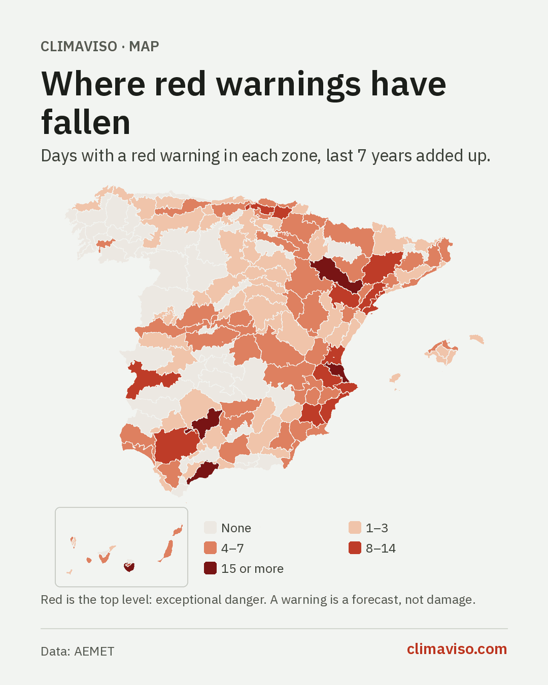
Red is the top level: exceptional danger. In seven years, 51 zones have not had a single red day, many of them in Galicia, Castilla y León and Castilla-La Mancha. The zones with the most:
| Zone | Red days, 2019–2025 |
|---|---|
| Litoral sur de Valencia | 24 |
| Ribera del Ebro de Zaragoza | 20 |
| Este, sur y oeste de Gran Canaria | 16 |
| Campiña cordobesa | 15 |
| Sol y Guadalhorce (Málaga) | 15 |
The red days in Córdoba, Zaragoza and Gran Canaria were almost all for heat; those in Valencia and Málaga, mostly for rain.
5. How many days a year have a warning
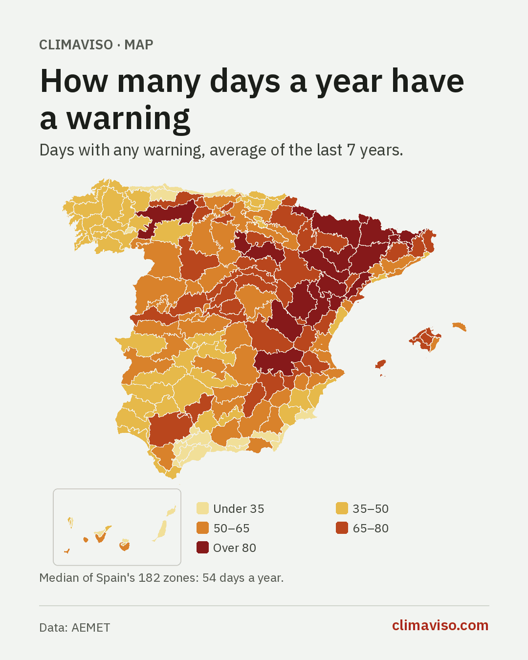
A typical Spanish zone has a warning about 54 days a year. Mountains multiply that: the Huesca Pyrenees add up to 129 days a year, the Lleida Pyrenees 123 and the Girona Pyrenees 107. At the other end are Ceuta and Melilla (about 18), Nevada y Alpujarras (20), western coastal Asturias (22) and the Axarquía (26). The full list is in the calmest places in Spain.
6. When the first heat warning comes
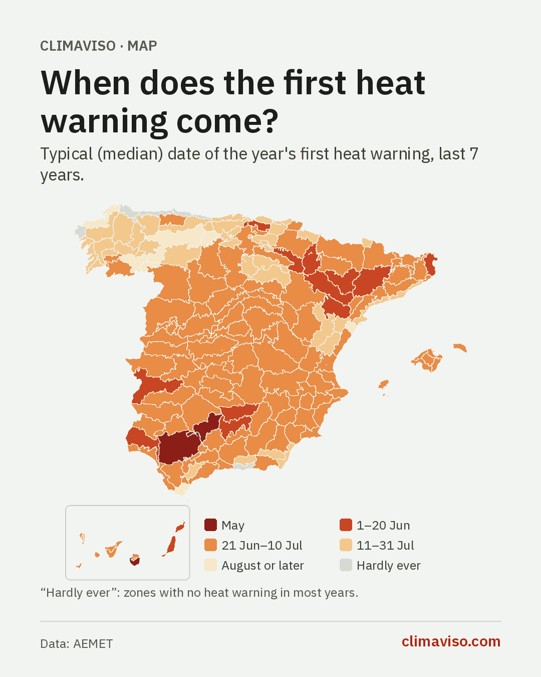
Warning summer starts in May. In southeastern Gran Canaria the year's first heat warning comes, at the median, around 24 May; in the Córdoba and Seville countryside, around the 28th; in Jaén and the Vegas del Guadiana, around 1 June. Across most of Spain it arrives between late June and early July.
In five zones, though, most years have no heat warning at all: the two coastal zones of Asturias, A Mariña in Lugo, western A Coruña and the Granada coast.
How to read these maps
The maps count warnings: forecasts that a threshold will be passed somewhere in the zone. They don't measure rainfall, temperature or damage. And each zone has its own thresholds: the yellow heat warning starts at 34 °C on the Cantabrian coast and at 38 °C in the Guadalquivir valley. A warning marks what is exceptional for that place; we explain it in what each colour means and Spain's 182 warning zones.
You're free to download and share these maps, crediting Climaviso, with AEMET as the source of the warnings. To see your town's warnings day by day, find it on the map.
Sources
- Warnings: official AEMET warnings, collected by Climaviso. Averages over the full years 2019 to 2025. A warning day counts once per zone, at its highest level; a day with warnings of several types counts under each type.
- Thresholds by zone: AEMET, Meteoalerta plan, annex 1 (31 May 2022).
Towns in this article
A warning is not damage; a zone is not a building.